
15 Best Waterfalls Near Maggie Valley, NC
One of the best things to do during the warm months from High Hopes Cabin is chase waterfalls. Western North Carolina has hundreds of them, ranging from five-minute roadside stops to half-day hikes, and Maggie Valley sits right in the middle of some of the best clusters in the state. Below are the 15 best waterfalls within a comfortable drive of the cabin, organized by area so you can string a few together into one memorable day trip.
Before you go: Several of these waterfalls sit inside Great Smoky Mountains National Park or U.S. Forest Service land, where parking for more than 15 minutes requires a park pass or day-use fee. The closest place to pick one up from the cabin is the Lake Junaluska Visitor Center, 91 N Lakeshore Dr, Lake Junaluska (visitncsmokies.com/visitor-center). Drive times below are estimates from High Hopes Cabin, 49 High Hopes Ln, Maggie Valley, NC 28751, based on typical mountain-road conditions — always double-check with GPS before heading out, since road closures and weather can change routes.
Closest to the Cabin: Cherokee Reservation
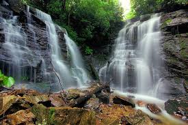
1. Soco Falls
A twin waterfall dropping into a shared gorge, right on the way to Cherokee.
- Distance from High Hopes: ~6 miles
- Drive time: ~10 minutes
- Trail length: 0.5–0.6 mile round trip
- Difficulty: Easy to Moderate (short but steep, with stairs and handrails)
- Elevation gain: ~100–180 feet
- Parking: Large paved lot with picnic tables and benches, just off US-19, 1.4 miles past the Blue Ridge Parkway turnoff. Free, no permit needed.
- Dogs: Allowed on leash
- Kids: Doable with supervision — steep steps and a slick lower spur to the base that’s best skipped with little ones
- Best season: Year-round; fullest flow in spring and after rain
- Photography: The viewing platform sits above the falls, so a zoom lens helps; overcast days reduce glare in the gorge
- GPS/Location: US-19, between Cherokee and Maggie Valley (35.492, -83.170)
- Nearby attractions: Blue Ridge Parkway entrance (Milepost 455.7), Cherokee’s Qualla Boundary shops and casino
2. Mingo Falls
One of the tallest waterfalls in the Smokies, reached by a steep staircase climb.
- Distance from High Hopes: ~25 miles
- Drive time: ~45 minutes
- Trail length: 0.3–0.4 mile round trip
- Difficulty: Moderate (about 160 stairs)
- Elevation gain: ~120–160 feet
- Parking: Small lot (15–20 spaces) at Mingo Falls Campground on Big Cove Road; free, no permit
- Dogs: Allowed on leash, though the stair climb is tough on most pets
- Kids: Manageable for older kids; not stroller-friendly
- Best season: Early summer, when mountain laurel and rhododendron bloom along the trail
- Photography: A wooden viewing bridge puts you close to the 120-foot drop — bring a lens cloth for mist
- GPS/Location: Mingo Falls Campground, Big Cove Rd, Cherokee, NC (35.532, -83.275)
- Nearby attractions: Oconaluftee Visitor Center and the south entrance to Great Smoky Mountains National Park, Soco Falls
Deep Creek, Bryson City
All three of these waterfalls sit on one easy loop inside Great Smoky Mountains National Park. Note: dogs are not permitted on any Deep Creek trail (GSMNP allows dogs only on the Gatlinburg and Oconaluftee River Trails), and a parking tag is required for stays over 15 minutes.
3. Juney Whank Falls
A 90-foot cascade you can view from a footbridge that crosses right in front of it.
- Distance from High Hopes: ~30 miles
- Drive time: ~1 hour
- Trail length: 0.5–0.6 mile round trip (steepest of the three)
- Difficulty: Moderate
- Elevation gain: ~190 feet
- Parking: Large lot at the Deep Creek trailhead, end of Deep Creek Road; GSMNP parking tag required for stays over 15 minutes
- Dogs: Not permitted on this trail
- Kids: Good for kids, with a short steep stretch near the start
- Best season: Year-round; spring wildflowers along the trail
- Photography: Shoot from the footbridge for a straight-on view of the full drop
- GPS/Location: Deep Creek Trailhead, end of Deep Creek Rd, Bryson City, NC 28713
- Nearby attractions: Deep Creek tubing run, Bryson City’s Great Smoky Mountains Railroad depot
4. Tom Branch Falls
A 60-foot falls visible across the creek, just a few minutes from the parking area.
- Distance from High Hopes: ~30 miles
- Drive time: ~1 hour
- Trail length: Under 0.1 mile from the trailhead (or add it to the loop)
- Difficulty: Easy
- Elevation gain: Minimal
- Parking: Same Deep Creek trailhead lot as Juney Whank Falls
- Dogs: Not permitted on this trail
- Kids: Very easy, great first stop for young kids
- Best season: Year-round; look for tubers floating past in summer
- Photography: Best shot from the benches across Deep Creek, especially with morning fog on the water
- GPS/Location: Deep Creek Trailhead, end of Deep Creek Rd, Bryson City, NC 28713
- Nearby attractions: Same as Juney Whank Falls — combine all three on one visit
5. Indian Creek Falls
A 25-foot falls tucked into a quiet cove, a bit farther down the loop.
- Distance from High Hopes: ~30 miles
- Drive time: ~1 hour
- Trail length: ~1.6 miles round trip from the trailhead
- Difficulty: Easy
- Elevation gain: Minimal, gently rolling
- Parking: Same Deep Creek trailhead lot
- Dogs: Not permitted on this trail
- Kids: Easy, wide gravel path the whole way
- Best season: Spring and summer for wildflowers and lush greenery
- Photography: A short spur leads to a landing right at the base — good spot for a family photo
- GPS/Location: Deep Creek Trailhead, end of Deep Creek Rd, Bryson City, NC 28713
- Nearby attractions: Deep Creek tubing run, Fontana Lake
Pisgah National Forest, Near Brevard
Transylvania County calls itself the “Land of Waterfalls” for good reason — this cluster along US-276 lets you hit five falls in one loop.
6. Moore Cove Falls
A 50-foot waterfall that pours over an overhanging ledge you can walk behind.
- Distance from High Hopes: ~48 miles
- Drive time: ~1 hour 15 minutes
- Trail length: 1.2–1.4 miles round trip
- Difficulty: Easy
- Elevation gain: ~160–200 feet
- Parking: Small paved pull-off on US-276, about a mile past Looking Glass Falls; fills fast on weekends
- Dogs: Allowed on leash
- Kids: One of the most kid-friendly hikes in the area — great for young children
- Best season: Year-round; can dry to a trickle in late summer droughts
- Photography: Step behind the falls for a unique frame looking out through the water
- GPS/Location: US-276, Pisgah National Forest (35.311, -82.777)
- Nearby attractions: Looking Glass Falls, Sliding Rock
7. Looking Glass Falls
A 60-foot classic plunge waterfall, and one of the most photographed in the eastern U.S.
- Distance from High Hopes: ~46 miles
- Drive time: ~1 hour 10 minutes
- Trail length: About 0.1 mile of stairs from the parking lot to the viewing deck
- Difficulty: Easy (paved with handrails, though slippery near the base)
- Elevation gain: Minimal
- Parking: Small paved lot right at the falls off US-276; arrive early or on weekdays
- Dogs: Allowed on leash
- Kids: Very kid-friendly; paved path down to the observation deck
- Best season: Year-round; morning sun shines directly into the falls, so late afternoon or overcast days photograph best
- Photography: Shoot from the lower platform for the classic straight-on shot; avoid midday sun glare
- GPS/Location: US-276, Pisgah National Forest (35.296, -82.769)
- Nearby attractions: Sliding Rock (5 minutes north), Moore Cove Falls
8. Sliding Rock
A 60-foot natural rock waterslide into an 8-foot-deep plunge pool — more a swimming hole than a hike.
- Distance from High Hopes: ~44 miles
- Drive time: ~1 hour 5 minutes
- Trail length: ~0.2–0.3 mile round trip to the observation deck
- Difficulty: Easy
- Elevation gain: Minimal
- Parking: Large lot; $5 per person day-use fee Memorial Day–Labor Day (free off-season, but no lifeguards or sliding)
- Dogs: Allowed on leash in the area; dogs may not slide
- Kids: Great for kids 7+ who can swim; lifeguards on duty in summer
- Best season: Summer (Memorial Day–Labor Day) for the full experience; the water stays about 55°F year-round
- Photography: Midday sun lights up the slide best; capture the action from the lower viewing platform
- GPS/Location: US-276, Pisgah National Forest (35.311, -82.787)
- Nearby attractions: Looking Glass Falls, Moore Cove Falls, Pisgah Center for Wildlife Education
9. Daniel Ridge Falls (Tom’s Spring Falls)
A 150-foot multi-tiered cascade that’s often overlooked despite easy access.
- Distance from High Hopes: ~49 miles
- Drive time: ~1 hour 15 minutes
- Trail length: ~0.9–1 mile round trip (skip the full loop and go straight there)
- Difficulty: Easy
- Elevation gain: ~110–160 feet
- Parking: Small lot off Forest Road 475
- Dogs: Allowed on leash
- Kids: Easy, gravel-road walking most of the way — good for strollers
- Best season: Year-round; especially scenic after rain when the multiple tiers are running full
- Photography: Shoot from creek level to capture the full multi-drop cascade
- GPS/Location: Forest Road 475, Pisgah National Forest, near Balsam Grove
- Nearby attractions: Cove Creek Falls, Pisgah Center for Wildlife Education
10. Cove Creek Falls
A quiet, less-crowded cascade tucked off the Daniel Ridge trail system.
- Distance from High Hopes: ~50 miles
- Drive time: ~1 hour 20 minutes
- Trail length: ~1.5 miles round trip
- Difficulty: Moderate
- Elevation gain: ~200–300 feet
- Parking: Small lot at the Cove Creek parking area off Forest Road 475
- Dogs: Allowed on leash
- Kids: Doable for older kids used to moderate hikes
- Best season: Spring and fall for the best water flow and fewer bugs
- Photography: Far less crowded than Looking Glass or Moore Cove — good for uncluttered long-exposure shots
- GPS/Location: Forest Road 475 near Cove Creek Group Campground, Pisgah National Forest
- Nearby attractions: Daniel Ridge Falls, Looking Glass Falls
Blue Ridge Parkway
11. Skinny Dip Falls
A series of three small cascades with a swimming hole, tucked just off the Parkway.
- Distance from High Hopes: ~53 miles
- Drive time: ~1 hour 40 minutes (Parkway driving is slow and curvy)
- Trail length: 0.8–1.0 mile round trip
- Difficulty: Easy to Moderate
- Elevation gain: ~180–210 feet
- Parking: Looking Glass Rock Overlook, Blue Ridge Parkway Milepost 417; free, fills on summer weekends
- Dogs: Allowed on leash; dogs enjoy wading in the pools
- Kids: Very popular family spot for wading (official swimming isn’t permitted per NPS rules, but sunbathing on the rocks is common)
- Best season: Summer for wading; year-round for the hike, but the Parkway closes in snow/ice
- Photography: The V-shaped cascade and pools are great for a long exposure — go early to beat the crowds
- GPS/Location: Blue Ridge Parkway Milepost 417, Looking Glass Rock Overlook (35.322, -82.835)
- Nearby attractions: Graveyard Fields (1 mile north on the Parkway), Looking Glass Rock, Sliding Rock
Highlands / Nantahala National Forest
Roadside falls and a genuine giant, all along the scenic US-64 corridor west of Brevard.
12. Dry Falls
A 65-foot waterfall you can walk completely behind and stay (mostly) dry.
- Distance from High Hopes: ~68 miles
- Drive time: ~1 hour 30 minutes
- Trail length: 0.25 mile round trip
- Difficulty: Easy (paved, with stairs and handrails)
- Elevation gain: Minimal
- Parking: Paved lot with accessible spaces and restrooms, right off US-64
- Dogs: Allowed on leash
- Kids: Very kid-friendly; the walk-behind path is a hit with children
- Best season: Year-round; after rain for the fullest flow (bring a light rain jacket for the mist)
- Photography: The walk-behind vantage point is the signature shot — use a fast shutter speed to freeze the spray
- GPS/Location: US-64, about 3 miles west of Highlands, NC
- Nearby attractions: Bridal Veil Falls (1 mile away), downtown Highlands
13. Bridal Veil Falls
A roadside, drive-adjacent waterfall — no hiking required.
- Distance from High Hopes: ~68 miles
- Drive time: ~1 hour 30 minutes
- Trail length: Roadside; no trail needed
- Difficulty: Easy — fully accessible
- Elevation gain: None
- Parking: Pull-off directly alongside US-64
- Dogs: Allowed on leash
- Kids: Easiest waterfall on this list — stroller and wheelchair accessible
- Best season: Year-round
- Photography: You can still walk up close to the base for a unique angle; best after a rain for fuller flow
- GPS/Location: US-64, 2.5 miles west of Highlands, NC
- Nearby attractions: Dry Falls (1 mile away), downtown Highlands
14. Whitewater Falls
The tallest waterfall east of the Mississippi River, dropping 411 feet down a rock face.
- Distance from High Hopes: ~80 miles
- Drive time: ~1 hour 50 minutes
- Trail length: 0.4–0.6 mile round trip (paved path plus a 154-step staircase to the lower overlook)
- Difficulty: Easy to Moderate
- Elevation gain: ~100–150 feet
- Parking: Large lot with restrooms and a picnic area; $3 day-use fee (honor system)
- Dogs: Allowed on leash
- Kids: Good for kids on the paved upper section; hold hands on the stairway to the lower deck
- Best season: Spring for peak flow, fall for foliage views across the gorge
- Photography: Two overlooks give different angles on the 411-foot drop — bring a tripod and shoot in morning light
- GPS/Location: NC-281, Sapphire, NC, near the South Carolina line
- Nearby attractions: Lake Jocassee views from the trail, Gorges State Park
Old Fort / McDowell County
15. Catawba Falls
A 100-foot waterfall at the headwaters of the Catawba River, on a trail that was rebuilt to be family- and dog-friendly.
- Distance from High Hopes: ~52 miles
- Drive time: ~1 hour 20 minutes
- Trail length: 2.2–3 miles round trip (River Trail to the base of the falls; add 580 stairs for the upper falls)
- Difficulty: Moderate (easy grade to the base, strenuous stair climb to the upper falls)
- Elevation gain: ~300 feet to the base; ~850 feet total with the upper falls and Ridge Trail
- Parking: Large lot at the trailhead (about 50 spaces) with restrooms; fills early on weekends
- Dogs: Allowed on leash — a well-loved dog-friendly trail with several creek crossings
- Kids: Great for families; the River Trail to the base is manageable for most kids, but skip the steep upper-falls stairs with young children
- Best season: Year-round; can be muddy after heavy rain, which is also when the falls look their best
- Photography: Multiple small cascades along the river offer several photo stops before you even reach the main falls
- GPS/Location: 3074 Catawba River Rd, Old Fort, NC 28762
- Nearby attractions: Old Fort’s downtown shops, Point Lookout Trail for mountain biking
Planning Your Waterfall Day Trip
These 15 falls naturally group into four day trips from High Hopes Cabin:
- Quick half-day: Soco Falls + Mingo Falls (under 2 hours total driving)
- Deep Creek loop: Juney Whank, Tom Branch, and Indian Creek Falls in Bryson City (one easy 2.4-mile hike covers all three)
- Pisgah waterfall crawl: Moore Cove, Looking Glass, Sliding Rock, Daniel Ridge, and Cove Creek Falls, all along US-276 — pack a swimsuit
- Highlands scenic drive: Dry Falls, Bridal Veil Falls, and Whitewater Falls along US-64, with Catawba Falls as a stop on the way home if you’re driving back via Old Fort
Whichever route you choose, come back to High Hopes Cabin for a soak in the private hot tub and a fire under the stars — the perfect end to a day of chasing waterfalls in the Smokies.